
I Can Still Read a Map. I've Started to Wonder If That Makes Me the Last One.
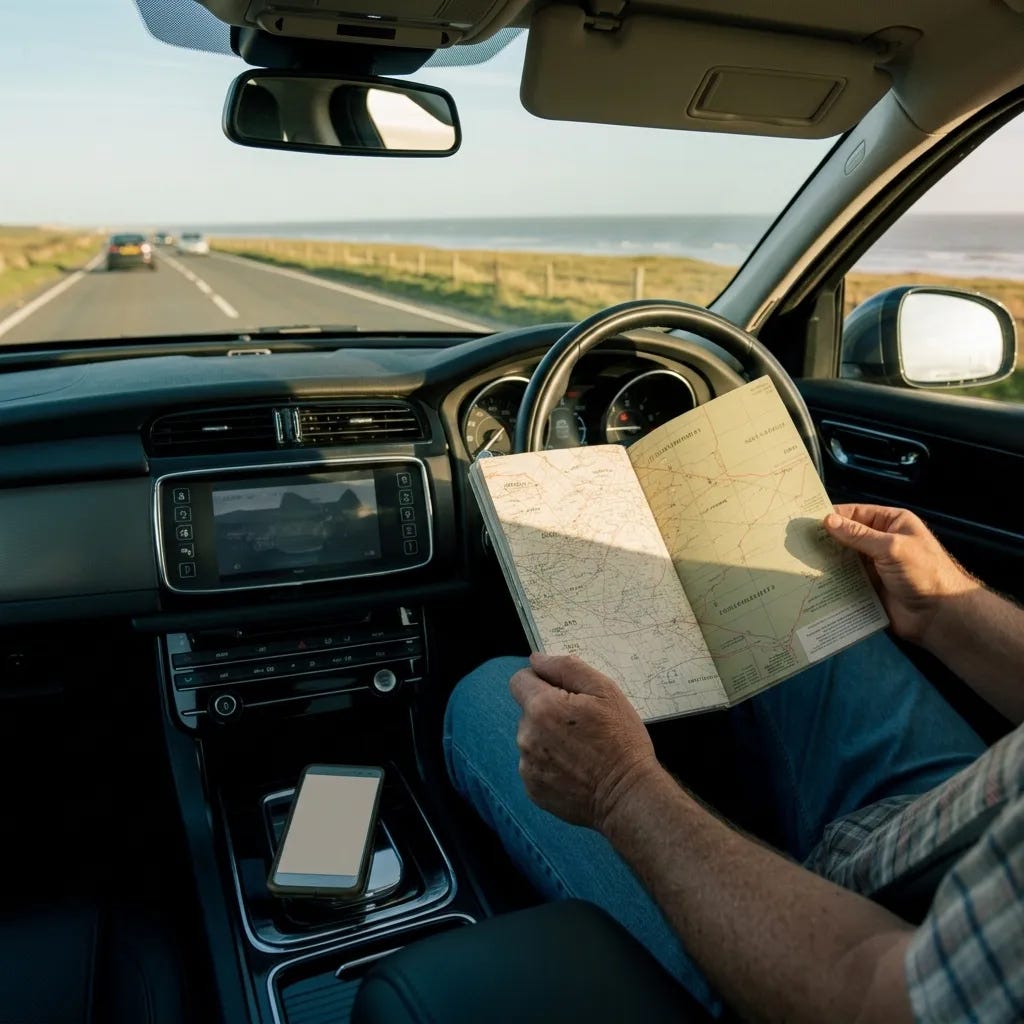
There is a road atlas in the back of my car. It’s been there for eleven years. It’s the kind of atlas that used to be in every car as a matter of course — A4 size, spiral bound, county by county, the motorways in blue and the A-roads in red and the B-roads in yellow, which always looked faintly optimistic.
The Darlington bypass is missing from it. That bypass opened in 2004. My atlas predates it. I know this because I once tried to navigate using it and found myself being directed with great confidence toward a road that had not existed for over a decade. The atlas had no idea. It had its own version of the world, and in that version the bypass hadn’t happened yet.
I kept the atlas anyway.
I have a phone now, of course. Everyone does. It sits in the cupholder and knows exactly where I am at all times, and it tells me, calmly and without drama, what to do about it. Turn left in two hundred yards. Continue on the A167 for eleven miles. Your destination is on the right.
The phone knows my coordinates. It does not know my context.
At sea, we made a distinction between position and situational awareness. Position is a data point. Situational awareness is what you know about everything around that data point — the weather coming from the northwest, the shallow water on the port side, the other vessel two miles off that hasn’t changed its bearing for twenty minutes.
You could know your exact position and still be in serious trouble. You could be one mile from disaster and have perfect GPS.
What we trained for was the model. The persistent, updating picture in your head of where you were relative to everything that mattered. Dead reckoning — the ancient practice of knowing where you are based on where you came from, how fast you’ve been going, and what direction you’ve been moving — wasn’t just a backup for when instruments failed. It was the habit of building the model continuously, so that when the instrument failed, the model was already there.
Officers who only trusted their instruments were a particular kind of navigational liability. They knew their position. They didn’t know where they were.
My father could fold an Ordnance Survey map in sixty seconds. Back to the original fold, correctly, every time. I timed him once. I never managed it in under three minutes. There is a particular technique — a sequence of folds that have to happen in a specific order, each one creating the conditions for the next — and my father had it so completely that he did it without looking, the way a person buttons a shirt.
I can fold a map. Not in sixty seconds, and not without looking, but I can do it.
I was with a younger friend recently — he’s thirty-four — who could not orient a paper map to the road we were on. Not wouldn’t. Couldn’t. He held the map and turned it and turned it again and there was a genuine uncertainty in his face about which way was which, because the map wasn’t telling him. The map required him to know something first — some independent fact about direction, about the sun, about the shape of the road ahead — before it could be useful to him.
He’d been navigating by phone since he learned to drive. The phone had always already known which way was which.
The thing about following instructions is that you don’t build a model. You build a sequence. Turn left, turn right, continue for eleven miles, arrive. The sequence gets you there, and if the sequence is right, it gets you there correctly. But the sequence leaves nothing behind. When you arrive, you know you’ve arrived. You don’t know where you are.
I know this is an old person’s complaint dressed up as an observation. I know this. I’ve been watching myself think it and I can see the mechanism.
But I don’t think it’s wrong.
I took a wrong turn deliberately the other day. Just to see what would happen — in me, I mean, not on the road. I was driving from a car park toward a road I know, and instead of going the right way I went the other way, toward a part of town I use less. And the phone immediately recalculated. It had a new route before I’d registered what I’d done. It accepted the wrong turn without comment and found me another way home.
I drove the wrong way for about ten minutes. The phone navigated me around it, faultlessly, with the particular unruffled competence of something that does not experience inconvenience.
At the end of the ten minutes, I turned the phone over and tried to hold where I was in my head. I could do it. I had a sketch — rough, approximate, missing details — of where I’d been and how I’d got there. The model was still building. The habit hadn’t died.
But it was effortful in a way it didn’t used to be.
The road atlas in the back of my car has a coffee stain on the cover. It has pencil marks in three counties from a trip I took twelve years ago, and I haven’t rubbed them out because I like having the record. The Darlington bypass is missing, and the Sunderland ring road has changed considerably since this edition, and there are probably a dozen other things wrong with it that I haven’t found yet.
It is not a reliable source of navigation data.
But when I open it and put my finger on the page and find where I am, I’m doing something the phone doesn’t require of me. I’m orienting. I’m building the model. I’m doing the old work of knowing, not just the new convenience of being told.
I drove home without the phone the other morning. Just to see. Took fifteen minutes longer than it needed to. Went a route I hadn’t gone in years. Turned out I knew it, without knowing I knew it — it had been in the model all along, waiting.
Getting properly lost, I’ve discovered, is now a leisure activity.
I’m not sure whether that’s a triumph or a warning. It might be both.
You’re seeing what I leave open. The rest goes further.- If you are paid subscriber no need for any further action but if you are free then …..
If this one landed, you can support it here:
Well, I don't know about the rest of the world, but considering all the hunters and hikers who go out to the backcountry where there isn't good cell service, all the current and ex-military types (like myself) that were trained extensively on how to use a map, all the young people who are currently turning away from technology as the panacea for everything, I think there are still plenty of us who can read a map (even if its less than before). Certainly, in the age of cars and planes, there are still people who ride horses - just a lot less of them.
I‘m still using maps too, even on travels. I don’t like to depend too much on my phone.